


- From
- Rs. 24,999*
- Nights
- 6
- Open dates
- 6
Field guide · Meghalaya
Cherrapunji (Sohra) travel guide
A limestone plateau on the wet edge of Meghalaya: India's tallest plunge waterfall, caves, and the stone steps down to the living root bridges.
- 340 m, one plungeNohkalikai Falls
- About 3,500 steps each wayDouble Decker trek
- Two nightsGood for
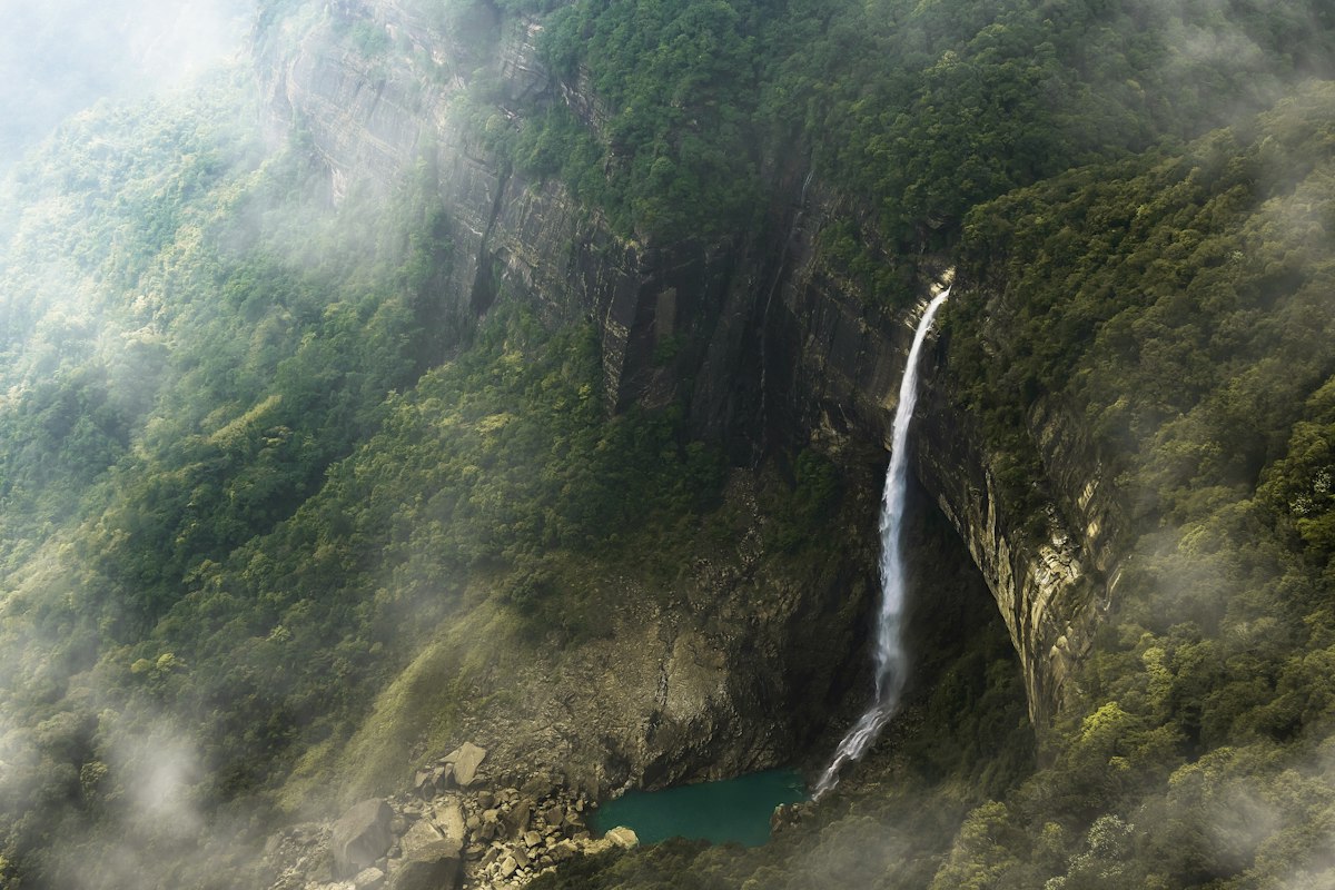
Photo: Nohkalikai Falls dropping from a forested cliff into a green pool, with cloud drifting across
Locals call it Sohra. The British wrote it as Cherrapunji, and that is the name in the record books for rainfall. The town sits on a plateau about 55 km south of Shillong that ends in cliffs, with the plains of Bangladesh spread out below.
Everything here comes from the rain: waterfalls off every edge, caves under the surface, and in the gorges below, the root bridges at Nongriat. It is the part of Meghalaya most people remember.
Overview
The wet edge of the plateau
Moist air from the Bay of Bengal crosses the flat plains of Bangladesh, meets the plateau wall and is forced up. The result is one of the wettest inhabited places on earth, with nearby Mawsynram. Almost all of that rain falls between about May and September.
The odd part is what happens the rest of the year. The plateau is thin soil over limestone, so the water runs straight off or straight down. In winter Sohra can be short of drinking water, and the great waterfalls shrink to threads.
Two seasons, two trips
In the dry months you get clear views, safe steps, open caves and blue pools under the falls. In the monsoon you get the falls at full roar, and often nothing else but cloud. Decide which one you want before you book.
The cave that named an age
Mawmluh Cave, just outside town, is over 7 km long. A stalagmite from it records a drought about 4,200 years ago that geologists chose in 2018 as the start of the Meghalayan Age. It is a serious cave, not a casual visit.

Things to do
Above ground, and below
-
Nohkalikai Falls
A single 340 m drop from the plateau into a green pool, listed as the tallest plunge waterfall in India. The name means "the leap of Ka Likai", from a grim Khasi legend about a mother, told on a board at the viewpoint. Flow is weakest from December to February.

Nohkalikai from the viewpoint -
The Double Decker root bridge, Nongriat
Around 3,500 stone steps down, past single root bridges and wire suspension bridges, to two living spans one above the other. The upper is about 24.6 m long, the lower 18.4 m. Start by 8 am, carry water, and save your legs for the climb back. Staying a night in Nongriat turns it from an ordeal into a pleasure.

Two spans, grown not built -
Rainbow Falls
A further walk past blue pools to a waterfall that throws a rainbow on sunny mornings. Sources disagree wildly on the distance, from 3 to 7 km. Only attempt it if you are staying in Nongriat or started very early.
-
Mawsmai Cave
The lit show cave: stalactites, pools underfoot and a couple of tight squeezes. Easy and popular. Closed or unsafe when flooded in the monsoon.

Mawsmai -
Arwah Cave
Rawer than Mawsmai, with marine fossils set in the walls from when this rock was seabed. Only the first few hundred metres are open. Bring a torch.
-
Wei Sawdong
A three-tier waterfall of about 51 m with turquoise pools in the dry season. The way down is a steep path with bamboo ladders. Wear shoes with grip.

Wei Sawdong's three tiers -
Dainthlen Falls
A wide fall you can walk right up to across flat riverbed rock, pitted with potholes. In Khasi legend this is where a giant serpent, the Thlen, was killed.
Practical info
Before you go
Best time
October to March for most people
The state tourism board recommends October to March for the Nongriat trek. November to February has the clearest skies. For big waterfalls come in June to September, and accept cloud, leeches and closed caves.
Getting there
From Shillong
About 55 km and two hours from Shillong by road, usually with stops at Mawkdok and the falls on the way. Shared taxis leave from Shillong's Bara Bazaar. Tyrna, the trailhead for Nongriat, is about 12 km beyond Sohra.
Fitness
The steps are the test
The Nongriat trek is not technical. It is 3,500 steps down and the same back up, in humidity. If stairs trouble your knees, bring a pole and take the climb slowly. A few weeks of stair practice before the trip makes a real difference.
Altitude
Not a factor
Sohra is at around 1,400 m and Nongriat far lower. Heat and humidity are the issue, not thin air.
Money and fees
Small cash
Viewpoints, caves and trails each charge a small entry fee, often with a camera fee, collected by the village. Carry plenty of small notes. ATMs in Sohra exist and are not dependable.
What to pack
Grip and dry bags
Shoes with good tread, a rain jacket, a dry bag, swimwear, a small towel, a torch for caves, insect repellent, and salt or socks against leeches in the wet months.
Build your packing list
Sohra is about grip and rain protection, not warmth. Tell the builder the month.
Open the Packing List BuilderFitness guideGo with Charkadam
Sohra, with a group
Cherrapunji and the root-bridge trek are on both of our Meghalaya trips. The trip pages have the day-by-day plans and say how the trek day is handled.
* Indicative starting price. The trip page shows the price for each date.
- From
- Rs. 27,999*
- Nights
- 10
- Open dates
- 6
Questions
Cherrapunji, answered
Yes. Sohra is the original Khasi name, and Cherrapunji is the name that came into use under British rule. The state uses Sohra officially.
Roughly 3,500 stone steps each way from Tyrna village. Most people take four to six hours in total, not counting time at the bridge.
October to March for clear weather, safe trails and open caves. June to September is the monsoon, when waterfalls are at their most powerful but cloud and rain can hide everything.
It drops 340 m (1,115 ft) in a single plunge and is listed as the tallest plunge-type waterfall in India.
There are natural pools near the Double Decker bridge where people swim in the dry season. Follow village rules, and do not swim when the water is high or fast.
Keep reading
Guides nearby
-
The whole state
Meghalaya
Root bridges, caves, waterfalls, Khasi food and how the seasons change all of it.
-
 The hill capital
Shillong
Markets, museums, music, and Khasi food stalls on every corner.
The hill capital
Shillong
Markets, museums, music, and Khasi food stalls on every corner.
-
 The clear river
Dawki and Shnongpdeng
When the Umngot is glass, when it is mud, and which village to pick.
The clear river
Dawki and Shnongpdeng
When the Umngot is glass, when it is mud, and which village to pick.
-
 Monastery town near the border
Tawang
India's largest monastery, high lakes, Monpa food, and the permits you need.
Monastery town near the border
Tawang
India's largest monastery, high lakes, Monpa food, and the permits you need.


