


- From
- Rs. 24,999*
- Nights
- 6
- Open dates
- 6
Field guide · North-east India
Meghalaya travel guide
A hill state of living root bridges, limestone caves, waterfalls off a plateau edge and a river clear to its bed, run by three matrilineal peoples.
- Guwahati, about 100 km from ShillongGateway
- October to AprilBest months
- None, carry IDPermit for Indians
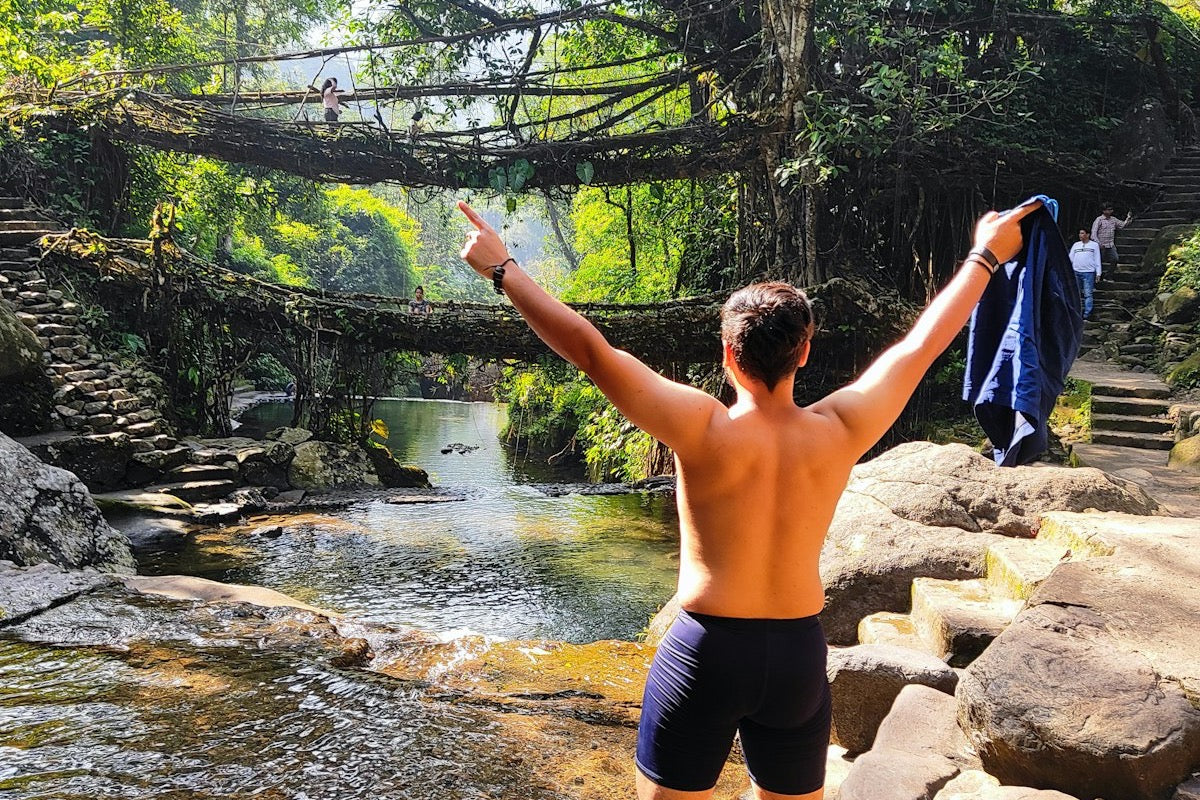
Photo: A double-decker living root bridge over a stream in the forest at Nongriat, with a traveller standing on the rocks below
Meghalaya means "abode of clouds". It is a plateau that rises straight out of the Bangladesh plains, and the wet air coming off the Bay of Bengal hits its southern edge and drops some of the heaviest rain on earth. That rain made everything visitors come for: the waterfalls, the caves beneath them, the forests, and the bridges that Khasi villagers grow from living tree roots to cross swollen streams.
This guide covers the state as a traveller meets it, from Guwahati up to Shillong and down to the southern edge. The places have their own guides: Shillong, Cherrapunji (Sohra) and Dawki and Shnongpdeng.
Overview
A plateau made by rain
There are three hill regions, named for the peoples who live in them: the Khasi Hills in the centre, the Jaintia Hills to the east and the Garo Hills to the west. Almost every first trip stays in the Khasi and Jaintia hills, within a few hours of Shillong.
The plateau is limestone and sandstone. Water has cut it into gorges at the edge and hollowed it into caves underneath. One of those caves, Mawmluh near Sohra, holds the stalagmite that geologists use to define the Meghalayan Age, the current slice of Earth's history, which began about 4,200 years ago. It was ratified in 2018.
Mothers' names
Khasi, Jaintia and Garo societies are matrilineal. Children take their mother's clan name. Among the Khasi the youngest daughter, the khadduh, is custodian of the family home and looks after ageing parents. It shapes daily life in ways you notice: women run most market stalls.
The living root bridges
A jingkieng jri is grown, not built. Villagers train the aerial roots of the rubber fig across a stream, often through hollowed betel-palm trunks, and wait. It can take around 15 years before a bridge carries people, and a mature one can last for centuries. The earliest written account is from 1844.

Food
Khasi food, plate by plate
Khasi cooking is rice, pork, fermented flavours and very little oil or spice by Indian standards. The place to eat it is a jadoh stall: a small room with a few benches and pots on a counter. Point at what you want.

Vegetarian? Say so clearly. Many dishes use pork stock.
Things to do
What a first trip should include
-
Walk to a living root bridge
The Double Decker at Nongriat is the famous one: two spans, one above the other, at the bottom of roughly 3,500 stone steps. It is a hard day on the knees and worth it. If you cannot manage the steps, there is a single bridge near Mawlynnong reached by a short walk.

The Double Decker, Nongriat -
Stand at the plateau edge
Nohkalikai drops 340 m in a single plunge and is listed as the tallest plunge waterfall in India. Around it, the Sohra plateau has a dozen more falls and viewpoints over Bangladesh. See the Cherrapunji guide.
-
Go underground
Mawsmai is the lit show cave, with a few squeezes. Arwah is rawer, with marine fossils in its walls. The state has some of the longest cave systems in South Asia, though the big ones are for cavers with guides. Caves flood in the monsoon.

Looking out of a cave near Mawsmai -
Float on the Umngot
In the dry months the river is so clear that boats appear to hang in the air. See the Dawki and Shnongpdeng guide for when that is true and when it is not.

The Umngot at Dawki, in the clear season -
Spend an evening in Shillong
Cafes, live music, a seven-floor museum of north-eastern cultures and the best food markets in the state. See the Shillong guide.
-
Laitlum
A ridge where the plateau drops away into a deep green valley. The name means "end of the hills". Go early. Cloud usually fills the valley by mid-morning.

Laitlum, "end of the hills" -
Mawlynnong
A Khasi village known for being very clean, a title that dates from a travel magazine in 2003. It now gets up to a thousand visitors a day at peak, and a 2026 report says the village closes to tourists on Sundays. Visit respectfully, or pick a quieter village.
Practical info
Before you go
Best time
October to April
October to February: dry, clear, cool. The Umngot is at its clearest, caves are open and trails are safe. Waterfalls are thinner.
March to May: warmer, with pre-monsoon showers. Falls start to fill.
June to September: the monsoon. Waterfalls are at full force and everything is intensely green, but caves flood, the river turns brown, steps are slick and views vanish in cloud for days.
Getting there
Via Guwahati
Fly or take a train to Guwahati in Assam. Shillong is about 100 km up the hill, around three hours by road in traffic. Shillong has a small airport at Umroi with limited flights. Shared taxis and buses run from Guwahati through the day.
Permits and ID
No permit for Indians
Indian citizens do not need an Inner Line Permit for Meghalaya. Carry government photo ID. In June 2025 the state told homestays and hotels to register every visitor through its tourism app, so expect to be asked for ID wherever you stay.
Altitude and fitness
Not high, but steep
Shillong is at about 1,500 m and nothing on the usual circuit is high enough to cause altitude sickness. The challenge is stairs: thousands of them, steep and often wet. Train your legs.
Rules and manners
Community-run sites
Most sights are on community or clan land and charge a small entry and camera fee that goes to the village. Carry small notes. Littering is taken seriously. Sunday is a quiet day in this largely Christian state and many shops close.
What to pack
Rain, grip, quick-dry
Shoes or sandals with real grip, a rain jacket in any month, quick-dry clothes, a dry bag for your phone, insect repellent and swimwear. A light warm layer for Shillong evenings from November to February.
Build your packing list
Meghalaya is wet and humid, not high and cold. Tell the builder the month and it adjusts the list.
Open the Packing List BuilderGo with Charkadam
Meghalaya, with a group
We run two Meghalaya trips: a seven-day trip that starts and ends in Guwahati, and a longer circuit from Mumbai and Pune. The trip pages have the day-by-day plans, so you can compare what each covers.
* Indicative starting price. The trip page shows the price for each date.
- From
- Rs. 27,999*
- Nights
- 10
- Open dates
- 6
Questions
Meghalaya, answered
October to April for dry weather, open caves, safe trails and a clear Umngot river. June to September is the monsoon, when waterfalls are at their fullest but caves flood and views are often lost in cloud.
No. Indian citizens do not need an Inner Line Permit. Carry a government photo ID, which hotels and homestays will ask for.
Five to seven days covers Shillong, Sohra and its root bridges, and Dawki without rushing. Add a day or two for the Jaintia Hills.
It is a descent and climb of roughly 3,500 steps each way from Tyrna village, usually four to six hours in total. No technical skill is needed, but it is hard on the knees and calves.
Most travellers find it welcoming and easy to get around. Use registered accommodation, carry ID, hire local guides on unmarked trails and be careful on wet steps and near fast water.
Keep reading
The places, one by one
-
 Falls, caves, root bridges
Cherrapunji (Sohra)
Nohkalikai, the steps to Nongriat, and the caves under the plateau.
Falls, caves, root bridges
Cherrapunji (Sohra)
Nohkalikai, the steps to Nongriat, and the caves under the plateau.
-
 The hill capital
Shillong
Markets, museums, music, and Khasi food stalls on every corner.
The hill capital
Shillong
Markets, museums, music, and Khasi food stalls on every corner.
-
The clear river
Dawki and Shnongpdeng
When the Umngot is glass, when it is mud, and which village to pick.
-
 Monastery town near the border
Tawang
India's largest monastery, high lakes, Monpa food, and the permits you need.
Monastery town near the border
Tawang
India's largest monastery, high lakes, Monpa food, and the permits you need.


